
Morimoto Fault Page
[Dept. Earth Sci., Kanazawa Univ.] [Ishiwatari Lab.]
Trench Excavation of the Morimoto Active Fault, Kanazawa City, Central Japan: Vivid Evidence for Holocene Thrust Fault and Recumbent Fold
The Morimoto Active Fault Research Group and Ishikawa Prefecture Environmental Security Division
Group members: Yoshiteru KONO (Chairman)*, Akira ISHIWATARI*, Akio OMURA*, Muneyoshi FURUMOTO*, Ichio MORIYA+, Akira SANGAWA#, Sakae MUKOYAMA@, Tomohiro NISHIYAMA@, Yasuhiro NAKAI&, and Masato AWA&.
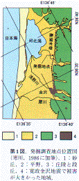
Å@The Morimoto fault has been estimated along the linear boundary between the Kanazawa plain on the Japan Sea coast and its eastern hills. The fault may extend from Kanazawa City (pop. 440,000) in a NNE direction for more than 13 km passing Morimoto, though its outcrop has never been found before. Subhorizontal Pleistocene beds forming the hills dip more and more steeply as approaching the fault, and the base of the upper Pleistocene Utatsuyama Formation is displaced more than 500 m vertically on both sides of the fault, suggesting 1 m / 1000 y. displacement velocity. The 1799 Kanazawa Earthquake which killed 15 people and destroyed 964 houses might be related to this fault.
Å@After the terrible Kobe Earthquake on 17 January 1995, the Ishikawa Prefectural Government started geological research of the fault and estimation of the social damage by the future earthquake. The Morimoto Active Fault Research Committee decided to dig a trench at the Umeda archeological site, which is located 8 km NNE of the City center. The excavated ditch of the Yayoi Period (3 centuries BC to 3 centuries AD) in this site showed unreasonable inclination, which suggested flexure of the land surface caused by the movement of the concealed active fault.
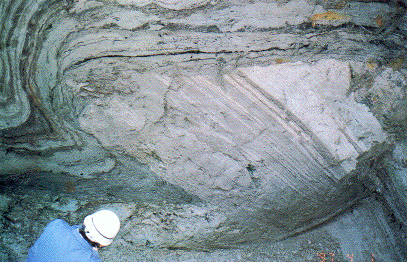
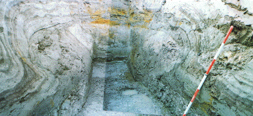
Å@The trench was 8 m long, 6 m deep, 1 m wide at the bottom, and elongated in a WNW direction, roughly at right angle to the fault strike. The photograph shows a lower half of the southern subvertical surface of the trench. The 4 m thick horizontal Holocene formation composed of soft, alternating sand, silt and clay (4430Å}80 y.b.p. 14C age at the base) covers hard mudstone and sandstone of the Utatsuyama Formation dipping 40 degrees to the northwest. This horizontal unconformity plane is displaced by a thrust fault, which strikes 35 degrees NE and dips 35 degrees NW. The vertical displacement measures about 1.0 m. The Utatsuyama Formation behaved as a rigid body without any fold or flexure, while the overlying Holocene strata behaved as a ductile body, displaying a recumbent fold in the lower part, which gradually migrating into gentle flexure in the upper part. All these deformations may have happened at the same time in a single earthquake event of 6.7 or more magnitude. The uppermost humic soil bed which participates in the flexure yields 14C age of 2060Å} 70 y.b.p., another Yayoi period ditch possibly dug along the foot of the land flexure yields 14C age of 1930Å} 60 y.b.p., and the Kofun period ditch apparently later than the flexure yields 1450Å}50 y.b.p. carbonaceous material. These data suggest that the earthquake may have occurred about two millenia ago.
Å@This is the first direct evidence for the Morimoto active fault, which has been estimated only by geomorphologic criteria. The sense of movement of the excavated fault (sea-side up), however, is completely opposite to that anticipated from geomorphology (hill-side up). It is possible that the fault we have found may be a minor bedding-slip fault associated with a major reverse fault, which may be located at nearby deeper place. It is also possible that the other estimated faults in the southern Kanazawa area have been responsible for the same earthquake, which may have been oversized for the Morimoto Fault alone. Further research is needed to find the expected major fault, and to depict detail of the last, prehistoric earthquake.